Category Archives: land use planning

in protest of the Bragaw extension

It has been talked about for years, and now known as ‘U-Med Northern Access’.  If completed, the project will join the northern part of Bragaw St. [north of Northern Lights Blvd.] to the southern portion [now known as Elmore Rd.] that now runs from 36th Ave. all the way south to God knows where [to Rabbit Creek Rd., but there’s a break or two in the southern leg before there — as an arterial, it goes no further than Abbott Rd.].  Anyway, the northern end terminates at the outer edge of the Mt. View neighborhood.   When all the sections are joined, this will one of the longest roads in the Anchorage bowl.

And that is all that this story has to do with Mt. View directly.  This is more of a lament about loss of ecological diversity — fundamentally a quality of life concern.

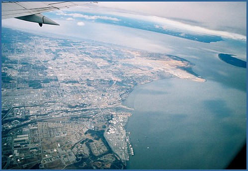
Google Maps recent aerial showing UAA, APU and Providence Hospital land holdings.

When I was first in Anchorage in 1971, the area the campus was in felt like the edge of civilization — as if you could walk away from the parking lot at AMU and right into a wild area leading directly to a path to a mountain valley above the tree line, without ever seeing any sign of human habitation.  Most but not all of this feeling is now gone, but we seem determined to eradicate it entirely.

I attended a Public Open House about the road project on Feb. 18th.  There were at least a couple hundred people there, and it seemed to me that about half were against the project, and the other half were undecided but interested in listening and finding out more.  There was a presentation by the road design engineer, Dowl HKM President Stuart Osgood, followed by a Q&A session where around 20 questions from the public were fielded.  Only one questioner seemed very positive about the road.

Osgood noted that around 250 written comments had been received thus far, and they fell into four main categories:

This is where you should read between the lines a bit.  By placing the word PARK in quotation marks, Dowl manages to heap on a bit of scorn and scolding, while sort of correcting the record — no, dear reader, this parcel is NOT a park, nor has it ever been.  It is develop-able land, owned by UAA and they can do what they like with it — and the fact that it is a large, intact chunk of boreal forest, wetland and wildlife habitat is immaterial.

If you need further reasons to be skeptical, note that travel times will not be decreased very much, according to their own 2011 study [see page numbers 50-52; pages 58-60 of the PDF].  What their data says when parsed is that travel times will be reduced less than five minutes at most [rush hours] after the new road segment is in place.

Osgood went on to note, “If you throw out all the comments in this first category, all of the ones that are left are constructive…” and without any suggestion the project is ill-conceived or should not advance.  Subtext: you dirty hippies are the only ones holding up progress, for no good reason.

This line of thinking is particularly egregious, reckless and irresponsible.  When Osgood says, it doesn’t matter that we are going to destroy this land’s current function as an ecosystem and little corner of urban wilderness, what he really means is it doesn’t matter to HIM.  And if HE wants to experience pristine, unspoiled Alaska all he has to do is gather some friends and family and ride their snowmachines out to their cabin, or drive down to Whittier and go out on their boat for a long weekend.  The public, half of whom do not have a pot to piss in have a much different perspective.  They might not even ever make it to Glen Alps or Bird Ridge, let alone Surprise Cove or China Poot Bay or a Bristol Bay fishing lodge or anyplace else you need money to get to — but they may very well walk around the trails at University Lake, Russian Jack, Kincaid Park and so forth.

Reasonable people may disagree about whether or not Anchorage has a traffic problem.  Sure, there are times when it gets frustrating making your way across town in a vehicle — but it’s never as bad as what you will find in Seattle, LA, Chicago, etc.  Why do we have traffic jams at all, when we have a relatively less densely populated city [in terms of average number of inhabitants per square mile]?  The answer [and it’s also the reason why building new roads and widening ones we already have is never going to reduce congestion] is we have created Anchorage [outside of downtown] using a bad development pattern.

I have been reading the book Suburban Nation [the 2010 Anniversary Edition, updated from the original 2000 version].  The architect authors are most famous for designing Seaside, Florida, a planned community that is not exactly my cup of tea — nonetheless, Seaside and other nice places to live have been created by deliberately avoiding Anchorage-style sprawl; and their book contains everything needed to understand the underlying principles, and is chock full of evidence of all of the negative by-products of following a sprawl model vs a traditional town model.  Excerpts:

Why have suburban areas, with their height limits and low density of population, proved to be such a traffic nightmare?  The first reason, and the obvious one, is that everyone is forced to drive.  In modern suburbia, where pedestrians, bicycles, and public transportation are rarely an option, the average household currently generates thirteen car trips per day.  Even if each trip is fairly short — and few are — that’s a lot of time spent on the road, contributing to congestion, especially when compared to life in traditional neighborhoods.

But even if the suburbs were to generate no more trips than the city, they would still suffer from traffic to a much greater extent because of the way they are organized.  The diagram shown here illustrates how a suburban road system, what engineers call a sparse heierarchy, differs from a traditional street network.  The components of the suburban model are easy to spot in the top half of the diagram: the shopping mall in its sea of parking, the fast-food joints, the apartment complex, the looping cul-de-sacs of the housing subdivision.  Buffered from the others, each of these components has its own individual connection to the larger external road called the collector.  Every single trip from one component to another, no matter how short, must enter the collector.  Thus, the traffic of an entire community may rely on a single road, which, as a result, is generally congested during much of the day.

Sounds familiar, eh?  Anchorage as it now exists consists of about 20 of the above-described cluster fucks.

The stated purpose of the Feb. 18th Open House was to select a route [from four alternatives].  Then the design will be further developed by the engineering team.  The “orange route”, the most direct of the four was declared the winner, and a slightly more detailed schematic was presented [above].  The concept includes: one traffic lane in each direction; three roundabouts; a bike lane each side of the roadway; a wide sidewalk one side and three pedestrian overpasses similar to the one across Raspberry Rd. on the way into Kincaid Park.  Osgood said, “You’d think it would be easy to build a 7/10th of a mile long road section for $20 million, but the budget is actually really tight.”  Indeed, the $20 million allocated seems low, considering there are still substantial issues associated with wetlands designation/design/permitting that Dowl has to deal with before construction begins; there will be a greater than typical extent of drainage infrastructure along the route; and it’s unclear to what extent the road will integrate into the surroundings.  Will the existing network of trails be reworked to tie into the new pedestrian bridges, or will trail segments be abandoned/orphaned in the process?

What will happen if $30 or $40 million is really needed to build the road as conceived?  Will the State Legislature appropriate more funds?  Or [more likely, if I had to guess] will some of the non-vehicular amenities be cut?  Some have said, it’s well known that $20 million is inadequate but the project proponents just want to get started on it, and with the current composition of the Anchorage Assembly, the Mayor, the State Legislature [conservatives and conservative majorities] it seems like a good time to pull the trigger on it.

Local activist Walt Parker, a former head of the State Dept. of Transportation and a quiet voice of reason in this and similar debates said at a recent meeting, “In the old days when a project like this would be proposed we would start by asking simple questions.  ‘Is it good for Anchorage?’ and ‘Would we be disadvantaged if we did not pursue it?'”  It seems that whatever process we now have in place to arbitrate long term transportation and land use planning [at a local, regional and state level] manages to skip these basic initial questions.

The lesser informed members of the public tend to be confused by the processes we employ.  When the State hires Dowl HKM to facilitate a public process, they are doing so as a player with a stake in the outcome.  If the public, lawmakers and other stakeholders approve, Dowl is hired to design the road and administer its construction.  They have made millions off similar projects.

They say we should trust their judgment.  And to their credit, Dowl is [in one sense] NOT selling snake oil here.  Their other road projects, including the southern portion of Elmore Rd., East 15th Ave. and several others are high quality.  They really are capable, as they tell us of doing a lot better job with roads than in the old days [missteps we are still living with every day] — including the integration of transit and trails, pedestrian and bike ways and better safety and sense of place.  What they do not excel at is determining whether it is wise to build and/or expand roads in the first place.  The public needs and deserves an impartial process, not subject to partisan political maneuvering, and run by expert planners who do not have an agenda or ax to grind.

My position might have shifted somewhat, had the two universities and Providence Hospital been more strident and pleading with the public that the road is badly needed, and they can’t live without it.  I don’t see this.  Their position is ambivalent at best — yes, access is good, better access is always welcome.  Does UAA have a Master Plan for its campus expansion?  How does the road tie into it?  Isn’t there a scenario where UAA/APU/Prov would benefit by NOT expanding into the undeveloped area [especially with more two- and three-story buildings separated by large surface parking lots]?  The 2011 report identifies the northern part of the site as a “Community Engagement Zone”, but they don’t really say what this is exactly — what they would like to build there and why it needs to be in that location.  Osgood noted during the presentation that the northernmost of the three new roundabouts will eventually link up with a east-west internal access road that will serve future university facilities.  But UAA might have better options, to redevelop and re-purpose existing sites that already have utilities and road access.

One of the questions from the public on Feb. 18th was something like, aren’t there more pressing needs we should be spending $20 million on?  Osgood said, he can’t answer that [it’s out of his area of expertise], and he assumed the question was rhetorical anyway [it wasn’t].

The Democratic coalition of the State Legislature is holding a hearing on a bill to pull the $20 million allocation for the project next week.  Their bill has no chance of passing unless some Republicans get on board.  But it is a good opportunity to provide feedback, and I encourage anybody with concerns on the matter to contact your legislators.

Tagged , , , , ,

wohlforth radio program on public involvement in government

I caught a repeat broadcast of a segment of KSKA’s Hometown Alaska tonight.  Host Charles Wohlforth and guests Lois Epstein and Anne Brooks talked about how public input is solicited and processed for public projects, and how the criteria and means and methods for public process are evolving.

It was fairly lively, considering the subject matter and that it aired in the polite, genteel world of KSKA.  [Well, I thought so, but I thrive on this sort of pastime.  Your results may differ.]  The overall take away from the hour: the old ways of communicating [attending a public meeting you found out about by reading the newspaper] are fractured; and no one here has any idea how to utilize the new channels.

Especially interesting: a call-in from a retired former State Highway Commissioner.  He said, compared with the old days:

  1. Anchorage has a weak Planning Dept.,  and there’s a disconnect with AMATS;
  2. AMATS/DOT do not brief the Municipal Assembly about ongoing work; and
  3. Nothing of substance can be learned by attending public meetings.

He further hinted that the non-transparency that prevails means that projects take everyone by surprise.  Why, for example are we talking about a road to Nome again?

Some other random notes I took during the broadcast, spoken by the host, panel or callers:

Washington State DOT uses Twitter extensively for public communication.
Anchorage Federation of Community Councils [FCC] email tree is a great way to receive various updates.  FCC budget has been cut 5 to 10 percent each year for several years in a row.
ADN is a popular forum, but comment sections are difficult to read because of their faceless, derogatory nature.
Project leaders seem to resent it when people in the community go straight to their elected representatives with concerns, bypassing a project team.
How can we involve youth in the community to a much greater extent?
Road/transportation projects have incredible momentum and are difficult to influence, even when found not to be fact-based or desirable [i.e., Knik Arm Crossing].  Even if discourse on a project reveals new information, cancellation or change of direction is quite rare.
If there are a lot of new projects, there will also be neglect and deferred maintenance of existing infrastructure — this conflict isn’t usually debated but it should be.
“No build” alternative is sometimes required to be included, but usually isn’t a serious consideration.
Public process is only as good as the people administering it.  And are they willing to listen?
Long-range plans such as Anchorage 2020 need to always influence project planning.  We are still siting new projects for other reasons [the state already owns the land, for example].
Sometimes politicians claim that support or lack of it for a project can’t be proven by what is stated by the public since so few people participate.  Polling, done in unbiased fashion can affirm or deny these claims.
Project engineers sometimes receive training where they are encouraged to empathize with commenters.
How do comments impact a project?  How do we know if comments are heard?  An effective structure of distribution and response.  Constructive comments will often be utilized.  Negative comments [“Your project sucks!”] are not useful or well received.

I would have liked them to get more into specifics.   I’ve followed a lot of projects over the past decade or so.  In the last couple years I submitted written comments for both the Muldoon Wal-Mart and the lease deal for First Tee at Russian Jack Springs Park

Wal-Mart was administered by the Planning Dept. and the public comments were well displayed in an online matrix with author name, date and complete comment.  All of the comments received were included.   For Russian Jack,  the Parks and Recreation Dept. project manager integrated excerpts from emails received into written narratives at various phases of the public process — but it would have been a lot more informative to know who wrote them, how many respondants were for or against the project, and all of the additional data, ideas and concerns contained in the complete and unabridged versions.  Considering the Russian Jack project [which is hopefully now on indefinite hold] was a lot larger and more objectionable, I thought it deserved a more thoughtful approach.

The panel touched on it briefly, but maybe it’s worth restating here: proposed solutions for integrating and disseminating comments should foucs on access and how comments will be archived for future retrieval. 

There are a lot of bloggers writing about public advocacy and community.  I ran across one from St. Louis the other day that’s a good example — the writer and commenters are informed, connected and engaged; the posts are thoughtful, lengthy and linked to sources.  If transportation planners and other municipal and state department heads started blogging their daily activities, intentions would be previewed far in advance of decisionmaking, and valuable input could be received on a continuous basis.  It’s time.

Tagged , , , , , , , ,

interview: patrick flynn

Patrick Flynn represents Government Hill, Downtown and Mt. View on the Anchorage Assembly.  His seat [the only Anchorage district with only a single assemblymember — all the other districts have two] was formerly held by the late Allan Tesche.  Flynn recently became Assembly Chairperson.  I asked him a few questions about current Anchorage issues via email.  The Q&A is also posted at Flynn’s blog.

Clark:  You have displayed a flair for explaining complex matters of municipal finance and funding to constituents and others.  What do you think are the top two or three issues in regards to taxes, budgeting, indebtedness and revenue that you would like people to understand better than most of us do?

Patrick:  First off, I’m gratified to hear that my attempts to explain some of the more arcane aspects of municipal activities have proven mildly helpful, so thank you for that.  As to some things that are important for folks to understand as we move forward, here are a few:

  • While size matters, the structure of MOA’s budget has the potential to more greatly impact our community.  Case in point, Mayor Sullivan’s 2010 budget uses state dollars for services, thereby reducing 2010 property tax assessments.  This is a change from recent years where taxes were assessed on the entire cost of providing municipal services and state dollars, when available, were used to provide tax relief.  The net effect – total tax dollars collected – is the same but by applying state dollars prior to setting mill levies means future tax capacity is lower than the tax cap otherwise requires.  So when you hear that rising labor costs require reductions in services that’s only part of the story – reduced tax capacity is also a major factor.  In the interest of full disclosure, I helped craft and voted for the final budget despite my discomfort with its use of state dollars.  Frankly, I didn’t feel the Assembly had enough votes to override the mayor’s line-item veto authority and the administration refused to negotiate on that point.
  • The 2010 ballot will see very few bonds, likely nothing from the School District and only a road & drainage bond for the municipality.  Given the general mood among taxpayers this is probably a smart move politically but risky financially for two reasons.  First, the current state-reimbursement program for school district bonds (which varies from 60 – 70%) expires on November 30, 2010.  If the legislature doesn’t vote to extend the program we’ve lost a terrific opportunity to reduce school bond costs (that said, I expect the legislature to extend the program). Second, the macroeconomic expectation is that interest rates will rise in the not-too-distant future.  If that comes to pass future bonds will be more expensive and we’ll likely kick ourselves for not issuing debt in the current low-interest rate environment.
  • Concerns about the level of property taxes have merit.  While Anchorage’s total taxation level is amongst the lowest in the nation, our reliance on property taxes is higher than most.  Those who have owned their property the longest, meaning their loans are paid off or nearly so, feel this the most as their property tax payments dwarf other monthly costs.  Unless and until we diversify our tax base discontent about property taxes will disproportionately affect our plans for the future.   While I’m no fan of sales taxes, that’s the most likely alternative.

Clark:  Mayor Begich was very enamored of public-private partnerships.  The Glenn Square Mall; negotiations with Wal-Mart over particulars of their Muldoon store proposal; redevelopment of the dead Safeway mall in Eagle River as a government service center; a proposed lease deal of part of Russian Jack Springs Park to First Tee; and the creation of the Anchorage Parks Foundation — as examples.  The public is sometimes suspicious of this kind of involvement by City Hall, and it can feel like the process engenders a lack of transparency and accountability, and other possible lapses that may be inappropriate for administering public funds.  What happens when public interest opposes business interest?  Are we losing a check and balance, when a newly-minted Municipal agency like the Development Authority is running a project with a private developer?  Are there certain types of projects that are only feasible, or exponentionally more effective if undertaken as a public-private partnership?

Patrick:  From my perspective the underlying question you’ve asked is, “When the city seeks out resources from beyond its revenue capacity, is the reduced taxpayer contribution worth the loss of control.”  As with many things the answer is not a simple yes or no.  Take the Glenn Square Mall – the developer has worked with the community but, despite what I feel were the best of intentions, has been unable to deliver in some areas (e.g. the lack of “magnet” businesses like a movie theater or a popular restaurant).  On the other hand Cook Inlet Housing Authority, which has worked very closely with the Mountain View community, has done a terrific job producing high-quality, lower-cost housing coupled with training for new homeowners and tenants.  The neighborhood effect has been quite positive and I love the looks of pride I see on owners’ faces, which manifests itself in a stronger neighborhood.

The short answer to your query is that there’s nothing inherently good or bad about public-private partnerships, but they do require a heightened degree of public vigilance.  And we should always ask why a private developer can’t or won’t advance a project without public involvement.  The answer(s) help inform whether the investment is a wise one.

Clark:  How much importance do you place on Land Use Planning, generally?  I’m concerned that we are getting a little carried away with road projects and other infrastructure that is starting to degrade our quality of life.  I appreciate the work that Anchorage Citizens Coalition is doing to increase awareness of processes and options we should consider, instead of continuing existing decisionmaking process and protocol.  There are legitimate concerns that both the Knik Arm Crossing and Highway to Highway projects are in conflict with the goals and aspirations of Anchorage 2020, our city’s master plan and template for growth.  What are some strategies we can use to protect and enhance existing assets?

Patrick:  While it may not be popular to say so, land use issues generally come down to basic economics – how do we achieve the maximum benefit for a scarce resource, Anchorage’s land base?  The good news is that economic arguments can drive the kind changes necessary to achieve Anchorage 2020’s goals.  More attractive land use, often achievable at relatively low cost, boosts land values and increases the desire for people and businesses to invest in our community.  The aforementioned CIHA projects are an excellent example.  So when faced with a project or proposal that one deems unpalatable I suggest looking at its costs and benefits, and then figuring out what alternatives can achieve greater benefits as less cost.

Clark:  What’s being done to plan sensibly for Anchorage’s utilities, in a future where we’re anticipating growth and shortages?  I’ve heard of a proposal for wind turbines on Fire Island.  How might the proposed merger of several regional electrical utilities help or hurt Anchorage’s interests?  A lot of us would like to see more emphasis on alternative energy.  Why are we not allowing and encouraging solar panel installations on homes and businesses, set up to feed the excess electricity back into the grid?  I think a lot of people were disappointed at the apperance of the huge electrical wiring towers on East Northern Lights Blvd.  Is there a way to better anticipate and accommodate the inevitable capacity increases without so much compromise to the aesthetic experience of Anchorage?  A lot of people are surprised to find out the extent of well and septic, vs piped water and sewer in Anchorage.  What work is underway, such as consideration of mandatory maintenance requirements, or increasing environmental controls to ensure the future viability of these systems?  Likewise for upgrading treatment at Pt. Woronzof.

Patrick:  A lot of planning is occurring, but progress is tough to discern.  As you know, talks about merging railbelt electrical utilities were recently revived and, given the population served, it’s a reasonable idea.  My understanding is that Chugach (CEA) and Matanuska Electric (MEA) both face significant challenges in financing necessary replacement of existing generation facilities.  Municipal Light & Power (ML&P) is in better shape, and it’s reasonable for ML&P customers to question whether a merger that might prove more beneficial to CEA & MEA customers is fair, but it’s unreasonable to abandon CEA & MEA customers if some sort of reorganization could achieve economies of scale that would benefit everybody.  Given that you’d think all the railbelt utilities would be pushing for change but they’ve been fighting amongst each other for 30+ years and I haven’t seen significant evidence of change.  Their need for capital may provide the opportunity since the State of Alaska is the only likely source, and can enforce consolidation as a condition of financing.

On the renewable front there’s plenty of wind, solar and hydro potential but I think their development likely requires us to contemplate three facts some may find uncomfortable:

  1. In order to encourage micro developments (e.g. solar panels on roofs) we need “net metering” regulations that allow utilities to purchase excess power production.  While that sounds simple, the Regulatory Commission of Alaska is taking it’s time developing those regulations to ensure they benefit independent producers without harming other utility customers.
  2. Because of the hugely cyclical nature of energy consumption in Alaska we’ll need to maintain significant hydrocarbon redundancy.  The most likely candidate is natural gas, though the Interior may find it advantageous to stick with their current fuel supply, coal.
  3. Maintaining natural gas demand sufficient to encourage necessary exploration and development of that resource requires significant and regular use, meaning industrial users.  Currently we have a Liquid Natural Gas export facility in lower Cook Inlet and the shuttered Agrium plant in Nikiski.  Those who understand the economics better than I inform me that we’ll not only need Agrium to resume operations but also at least one more petrochemical facility in Cook Inlet.  While that new facility is unlikely to be in Anchorage (we don’t have enough land) it wouldn’t surprise me to see it at Point MacKenzie, near Nikiski or near Tyonek.  In other words, we’ll need further development not for development’s sake, but for conservation’s sake.

The good news about all this is that we have relatively high levels of awareness about all these concepts.  The bad news is that there’s no clear route forward, nor consensus about the direction of that route.

Clark:  Is Anchorage ready for another quake like the one in ’64?  There were, I belive less than 50,000 people here then; and 275,000 now.  Would there be a level of death and destruction that’d be overwhelming?

Patrick:  Once again, this isn’t a yes/no question.  A lot depends on factors well outside of our control.  Does the quake strike during a relatively mild season or in the depths of winter?  Are natural gas, water and electrical distribution networks severely compromised or are residents on their own for days or weeks before service is restored?  Does the Port of Anchorage, through which more than 80% of our goods flow, remain serviceable (as it did in 1964) or is it devastated (as Seward was)?  What is the condition of other transportation networks like roads, rail and airports?

The common denominator for these questions is resources – which ones are available and how do we allocate them?  The good news is that Anchorage’s Office of Emergency Management is well-versed in the Incident Command System (something I’ve worked with for many years) and, I think, would make good decisions in helping react to any natural disaster.

Clark:  Much has been written about the condition of our municipal bus service, People Mover.  I think bicycling is the best way to get around Anchorage.  I would much rather be most of the way someplace, regardless of temperature and conditions, than standing at a transit stop for more than an hour, then boarding a bus for a slow crawl to someplace other than my final destination.  Low ridership is a symptom of inadequate service, but also used as a justification for not making improvements that cost money.  Can’t we do a little better?  I am hoping the business community will realize that having viable mass transit benefits them, and they will begin to demand it.

Patrick:   As one of the point people in recent budget negotiations, one of the most encouraging aspects of that conversation was the near-universal support for public transit.  Can we do better? Absolutely.  Will we see dramatic growth in the near future?  Because of economic concerns I doubt it, but Anchorage’s business community recognizes the importance of this service and I foresee an improving future.

Clark:  I was pretty disappointed at the reaction by local business to proposed traffic lane and pedestrian amenities at both Fireweed Lane and Spenard Rd.  Especially given the existing conditions are unsafe and unsuitable.  Maybe the proposed redesigns could be improved, but leaving everything as is would be unfortunate.  I find it notable that Anchorage lacks neighborhood commercial centers — where on-site parking is not mandated, and on-street parking is provided and there are substantial landscape and other infrastructure/amenities.  We have nothing like this, outside of downtown.  I began to try to sketch some possibilities of how Mt View Dr. could be reworked in this way, and a little about the pros and cons of the concept.  Will advocates for smart growth ever win hearts and minds in Anchorage?

Patrick:   Once again, this discussion reverts to economics.  In digging into the Spenard Road issue one of the concerns I heard from the business community was a concern less about the finished product than surviving the reduced patronage during construction.  One potential solution, beyond better communications between stakeholders, is to address this project a few blocks at a time.  That could achieve two results: opportunities to review project details for efficacy and reduced total neighborhood impact.  A potential detriment is the loss of economies of scale, but if the reconstruction of “Romig Hill,” the portion of Spenard linking Hillcrest Drive and 19th Avenue, increases pedestrian traffic it may help drive other segments of the project forward and provide a road map for future endeavors.

Clark:  Homelessness seems like Anchorage’s big issue at present.  A string of deaths at homeless camps; more visibility of homeless persons than ever; and a varying amount/availability of social support systems have contributed to a volatility and sort of deeply-rooted cynicism about how to approach and treat the various issues.  Nontraditional/novel programs like Homeward Bound seem to have the greatest success in breaking people out of a cycle of street living and drug/alcohol dependencies.  The public is weary of what looks like endless studies conducted, and ready for more action — but not necessarily the sort of action that is often proposed, i.e. pack them all up and ship them to Santa Monica [or somesuch].  Any insights…?

Patrick:   By the time I finish responding to these questions I expect you will have already read an article in the ADN discussing a proposed “Housing First” initiative.  The idea, pioneered in Seattle, is to get chronic public inebriates who disrupt neighborhoods and inflict high community costs via their use of local services into housing.  Unlike many other models, these individuals would not be required to quit drinking but results elsewhere indicate their consumption drops, community costs fall and they become more receptive to treatment options.  Some of my colleagues who initially opposed the concept have warmed to the idea and, since most of the other ideas we’ve tried haven’t solved the various issues, I’m hopeful we’ll give it a try.

Clark:  What are two or three areas where Anchorage will be the most challenged in the next 20 years or so, and what could we be doing now to ease the transition and deal with uncertainties and our expectations?

Patrick:  Just one thing, though it’s multi-faceted and again returns to the importance of economics.  As a recent ADN editorial discussed, Alaska’s economy is heavily reliant on oil.  To one degree or another that will change and how we manage that change will have huge impacts on all of us.  Effectively leveraging our natural attributes such as an outstanding environment, global logistical position and abundant resources is important.  Creating a vibrant community with attractive land use, vibrant cultural opportunities, a strong education system and, yes, reasonable taxes, helps attract and retain the people we need to continue our community’s maturation.  We know our challenges – that’s the easy part – but we don’t agree on what we want to be, and that’s the hard part.

Tagged , , ,

title 21 rewrite dumbing down continues

The Anchorage Citizens Coalition continues to give a full court press to informing the public of the theft underway, vis. the future appearance of the community and the hollowing out of its core values.  [Show ACC some love for their efforts, I did!] 

ACC chart showing how far the rewrite has strayed from the vision, in regards to open space.  [Click on the image for a larger version.]

ACC chart showing how far the rewrite has strayed from the vision, in regards to open space. (Click on the image for a larger version.)

The latest two communiques from ACC about discussion and changes to the Title 21 Land Use Code rewrite‘s provisions for open space were jarring!  This is the first time I felt like the revised Title 21 could actually turn out worse than the current one.  Feb. 25th:

This draft requires no PUBLIC open space, leaving all of us responsible for paying for additional park space as Anchorage becomes more dense..

Clarion Assoc (that wrote the first drafts of the proposed code in direct response to Anchorage 2020 goals) recommended 100 feet of PUBLIC OPEN SPACE per 1000 sq ft of developed lot.  A developer would provide land or a “fee in lieu” to a municipal parks account.  That provision has been dropped altogether.

 The Anchorage 2020 comprehensive plan clearly identifies preservation of open space as a key community value.  Think of what Anchorage will look like, without the wooded buffer zones that exist now.  We can continue to take these for granted, up until every last one is defoliated.  When that happens, we will be a lot more likely to be breathing bad air a lot of the time, due to a lack of windbreaks.  Habitat destruction for moose and other wildlife will be complete.  And protection of creeks and aquifers will be at an all-time low.

ACC representative Cheryl Richardson was the only Anchorage citizen to attend a Feb. 19th meeting about the open space provisions.  Besides Municipal Planning Dept. staff and members of the Anchorage Assembly, there were four homebuilder developers in attendance.  Some of the developers’ comments on private open space provisions [followed by Cheryl’s comments in parentheses]:

  • If we make housing here too expensive, it will drive more people to live in the Valley.  (Multifamily development costs are less under proposed code than current code.)
  • Not everyone needs a flat yard. (Staff wanted the private space to be usable by young children and folks in wheelchairs.)
  • Why provide open space outdoors when our winters are so long.  (Because it’s our summers that bring most people out of doors.)
  • If you have a child, then don’t rent an apartment that doesn’t have play space.
  • Is there a requirement for the open space to have direct sunlight? (Answer:  No.)

The developers appear to be using the perceived lack of public interest to take over the debate, and they appear to be getting away with it.  If people knew what was at stake, there would be an organized opposition movement against these rewrite revisions.  We have heard the argument — we cannot afford to provide the amenities you want, and if you make us do it we will ‘take our ball and go home’, i.e. move to Mat-Su and stop building in Anchorage — before.  It’s a scare tactic and it rings hollow.  Developers always grandstand like this, and will say the sky is falling right up until when the new regulations become inevitable.  Then they will instantly adapt.

Maybe I can frame this without seeming to engage in class warfare?  Effectively we are ceding control of parameters that can make our lives much better, to people who have already acquired enough wealth that none of it will affect them.  Why don’t these homebuilders want the tenants of the units they build to have nice yards and enjoyable surroundings? 

Typical Anchorage infill housing development, this example from east Anch.  Street dominated by cars and garages, yards are small and narrow, no alleys, little concern for building orientation to natural features.

Typical Anchorage infill housing development, this example from east Anch. Street dominated by cars and garages, yards are small and narrow, no alleys, little concern for building orientation to natural features.


Does it get any worse?  Yes!  Four-plex apartments, street sides windowless, entire area between buildings and street 100% paved, no landscaping.

Does it get any worse? Yes! Four-plex apartments, street sides windowless, entire area between buildings and street 100% paved, no landscaping.

I’m not saying the homebuyer doesn’t have a legitimate concern [why should they be forced to pay for amenities and features they don’t think they need?].  But it also makes financial sense to stick to a vision — and those homes that do have useable yards, a woodsy setting,  and are well oriented to prevailing sunlight and viewsheds will hold onto their value a lot better than those built without a thought to their sites. 

Anchorage is full of examples of subdivisions where the facade of the house is dominated by the garage doors, where there are no sidewalks and little street parking availability; a lack of dedicated pedestrian ways; no alleys; where the natural landscape was completely obliterated in order to build the new streets and houses. 

Further discussion of the history of public open space provisions during the rewrite, from ACC, Mar. 4th:

But, in 2004, staff gave up on having developers either provide public open space with construction or paying a fee in lieu to a fund that would provide open space.  This left the burden on the rest of us to approve park bonds to pay for adding public open space as Anchorage becomes more dense. 

The decision feels like a “plot” because it was not publicly discussed beyond that 2004 workshop to which the public was not invited.
  Even Planning and Zoning Commission members were surprised to learn in 2008 that public open space had been proposed in earlier Title 21 drafts and then dropped.  Having three minutes in a public hearing to explain the open space problem to P&Z along with several other issues does not constitute meaningful public discussion.

Of all the issues summarized in Chris Duerksen’s 2004 report, I found dropping public open space the most disturbing.  What do you think?  Here’s the link: http://www.muni.org/iceimages/planning/Duerksen_wkshp_report.pdf

I find it disturbing as well.  Too much of what happens in Anchorage seems like an inside job, intentionally flying under the radar.  If you aren’t concerned about any of this, just sit back and relax.  If you are concerned, suggest to your favorite mayoral candidate they should start talking about it.  And think about getting involved in another way, and talking to friends and neighbors.  Or else you won’t know what you’ve got ’til it’s gone.

This Eagle River subdivision is the poster child for bad development.  Soils from the denuded hillside began washing down onto property below.  Before 2007 there was nothing in local codes to make erosion control mandatory.

This Eagle River subdivision is the poster child for bad development. Soils from the denuded hillside began washing down onto property below. Before 2007 there was nothing in local codes to make erosion control mandatory.

The street side width of each building is asphalt paved all the way across.  There are small yards between the buildings but theyre sloped.

The street side width of each building is asphalt paved all the way across. There are small yards between the buildings but they're sloped.

10 feet from the back of the buildings to the undeveloped property next door.  This strip counts as part of the required yard, even though its continuously sloped, in the dark on the north side and theres no door opening onto it from the house.

10 feet from the back of the buildings to the undeveloped property next door. This strip counts as part of the required yard, even though it's continuously sloped, in the dark on the north side and there's no door opening onto it from the house.

These are 4-BR, 2-BA, 1,340 sq. ft. attached units, offered in the low 200s, by the way.  Apparently marketed to families who dont need a yard.

These are 4-BR, 2-BA, 1,340 sq. ft. attached units, offered in the low 200s, by the way. Apparently marketed to families who don't need a yard.

Tagged , , , , ,

redevelopment potential on mt. view dr.

In 2006 the Land Use and Housing Subcommittee, part of the Mt. View Neighborhood Planning effort underway then spent some time in visioning sessions about how the commercial corridor could be revitalized.  Lately I have been wondering what that might actually look like, and about the reasons for pursuing it.

First a little history.  The main drag in Mt View is called Mt. View Drive.  Until 1965 or thereabouts it was called the Palmer Highway and it was part of the main route north out of town to Eagle River and the Mat-Su Valley that opened sometime in the ’40s.  In 1965 the new Glenn Highway was constructed to bypass Mt View a few blocks to the south.  It was not a positive development for Mt View. 

From all along the winding route of Mt. View Drive there is a very wonderful panoramic view of the Chugach Mountains to the east and south.  The street follows a bluff line and sits on a plateau relative to the Glenn Highway and the rest of Anchorage to the south.  You can get some sense of it looking at the photo on the header of this blog site.  [I should find some better photos — it’s really great, trust me.]

At this point in time it feels like a prime opportunity to reinvent Mt View’s commercial center.  But to do so will require that all residents, stakeholders and government rally behind a plan.  I would like to start a discussion and air some ideas.  For the purposes of the discussion we will look at properties along the north and south sides of Mt View Dr along a two-block run between N. Bragaw St. and Klevin St.  But the principles could just as well be expanded east and west.  There is still a lot of vacant commercial property surrounding the study area, and uses that are “place holders” such as mini-storage and trailer parks.

All of the buildings on the properties in our two study blocks now are at the end of their useful life.  The land use is locked into a highway strip development pattern that remains from the earliest days of the road.  There is some parking for businesses, but although about two thirds of the property area is paved with asphalt, only one third of the existing parking spaces are legal, i.e. comply with current dimensional standards for stalls and maneuvering clearances and access aisles.  Most of the parking lots cannot be reconfigured to comply. 

The type of development that would make for a safe and vital neighborhood center isn’t possible because of a lack of exploitable potential.  Current municipal zoning mandates on-site parking, and there is minimal on-street parking.  This means that if someone wants to open a restaurant with 12 tables, they must have enough adjacent land to install a 48 car parking lot [and all that entails — parking lot lighting, landscaping, storm water drainage and treatment, etc.].   To an extent these are the same problems that face all of Anchorage.  The Anchorage 2020 plan called for Town Centers to be developed.  The underlying philosophy is quite similar, but a neighborhood center is much smaller footprint [micro compared to macro].  It’s relatively cheaper and smarter to redevelop Mt View because the infrastructure is already here and the street is backed up by the most densely populated part of Anchorage.

In order to redevelop Mt View Dr in this best way possible there are two major prerequisites: 1. a plan for street improvements that will provide substantial on-street parking; and 2. a revised zoning designation that will allow construction of commercial space without any requirements for on-site parking.  These two changes will mean businesses will have a great deal of flexibility because resources needed by all will be public and shared.  More businesses and residents located in a compact area will mean more amenities and parking will be available, and sensible planning will mean we can capture the intrinsic value of these properties.

If Mt View becomes a revitalized commercial center that attracts patrons from outside the neighborhood, every existing resident and business will also benefit.  If new residential units are provided along with new business and retail space, the presence of the residents will have a domino effect: the residents will supervise the area at all hours, in concert with business owners and lead to increased desirability and business vitality.

Key components to making the scheme work for residents, business and car traffic are: pedestrian access; traffic calming; parking; viewshed protection and view “captures” [through master planning and acquistion of “air rights” on adjacent sites]; and application of smart growth fundamentals and sustainable design principles.

Change is always really difficult.  But please understand in this case there are consequences for not changing.  We have already learned, I think that Mt View will not become a destination based on any single new business, or upgrades made that aren’t part of a coherent grand scheme. 

The drawings that follow are rough, and there’s not a lot there.  I want to continue to work on them and add detail to the buildings; landscaping, curbs and sidewalks; people and clouds and so forth.  But they will give some idea of potential.  Shown are the conditions in 2008 and visions for 2016 and 2028.

Here are some numbers for the two block study area:
2008
Total parking: 154 spaces — 7 on-street; 98 on-site [conforming], 49 on-site [nonconforming]
Retail space: 39,000 sq. ft.
Living units: none
Office space: none

2016
Total parking: 182 spaces — 50 on-street; 124 on-site [conforming], 8 on-site [nonconforming]
Retail space: 55,000 sq. ft.
Living units: 32 apts. — 13 1-BR; 5 studio; 10 2-BR; 4 3-BR
Office space: 7,400 sq. ft.

2028
Total parking: 155 spaces — 51 on-street; 104 on-site
Retail space: 69,000 sq. ft.
Living units: 84 — 24 1-BR; 5 studio; 30 2-BR; 18 3-BR; 1-4 BR; 6 3-BR town houses [variety of sizes and types of units available, accommodating 200+ people]
Office space: 7,400 sq. ft.

Study area of Mt View Dr in 2008, looking SE.
Looking west on Mt View Dr, showing existing strip development.

Looking west on Mt View Dr, showing existing strip development.

Looking SE in 2016.  Traffic lane revisions, on street parking, a few new buildings.

Looking SE in 2016. Traffic lane revisions, on street parking, a few new buildings.

Looking west along the study area of Mt View Dr in 2016.

Looking west along the study area of Mt View Dr in 2016.

And a similar view in 2028!

And a similar view in 2028!

Looking east in 2028, showing a variety of housing and commercial buildings.

Looking east in 2028, showing a variety of housing and commercial buildings.

West part of study area in 2028, looking SW.

West part of study area in 2028, looking SW.

East end of study area in 2028.  Apartments oriented toward territorial view.

East end of study area in 2028. Apartments oriented toward territorial view.

2028 looking SE.  Compare to similar 2008 view at the beginning!

2028 looking SE. Compare to similar 2008 view at the beginning!

Update 12-18-08: Looking over some meeting notes from the Business Focus Group of the Mt View Neighborhood Plan [currently being facilitated by Agnew::Beck Consulting], I see some similar plans are already being discussed.  Thanks to Heather at A::B for pointing this out.

Tagged , , , , ,

begich on anchorage transportation priorities

More from Cheryl Richardson in an email:

Senator Elect Mark Begich spoke to the Anchorage Chamber of Commerce yesterday. Here are his transportation comments as reported by an Anchorage Citizens Coalition member.  

There is strong demand for ride sharing programs, with a waiting list of, I believe, 600 people to participate in van pools from the Valley to Anchorage.
There should be funding for a train/rail option to the Valley before more costlier options like the bridge are promoted.
All transportation projects should be determined by local/community support. [emphasis added]
Financing and community support will drive the Knik Arm Bridge.  Funding updates are overdue and the bridge will cost $1 billion – with no plan to pay for it. Other problems include opposition from Government Hill, lack of a financial plan and availability of other solutions.
More road building leads to less congestion.  He was not joking, and referred to all of those roads he helped to build in Anchorage (including the Dowling Road Extension and the 48th Avenue from Boniface to Bragaw/Elmore through Bicentennial Park that the Mayor renamed Martin Luther King Jr. Ave.)
Sen. Begich was VERY bullish on the need to build the H2H scheme, focusing on making a seamless highway connection from Glenn to the Seward highway. He spent a lot of time on this, and said that it’s a choke point for trucks and commerce from the ports.  Is that really true?
He was bullish on the Port of Anchorage, saying it’s happening. He further noted it was vital to U.S. defense/security needs as one of 16 critical defense infrastructure ports. The talking points sounded like the same talking points as former Gov. Sheffield in the talk he gave in November when he pretty much said the port’s expansion is vital to U.S. defense needs.
Personally, I was most concerned about the Mayor’s views about roads = less congestion and his strong support for the H2H project as it is currently envisioned as a major highway project. But the Mayor was a backer of the LRTP that said the same thing, as we all know.
However, as the Mayor said, if there are strong community views shown, the planners should listen and plan accordingly.

Interesting stuff.  I have been a strong supporter of all of Begich’s campaigns, and he’s been the best friend in city government Mt. View ever had [he even announced his run for the U.S. Senate here, earlier in the year]. 

I always find his views to reflect a strange mix of progressive and reactionary ideals.  He seemed woefully ill-informed on green design initiatives until sometime in ’06 when Seattle Mayor Greg Nickels took him aside and educated him.  Now we are replacing street lights and making several other modifications to cut energy usage.  I just wish he would experience a similar epiphany in regards to long term transportation planning and smart growth.  I think it will just take more time.

Tagged , , , ,

mt view supports mass transit

Just received this in an email from Cheryl Richardson of Anchorage Citizens Coalition:

Last week, Mountain View Community Council adopted [a] resolution asking the State to help pay for operating People Mover.  The resolution goes next to Fairview Community Council.
While the state’s general fund has been tapped for several hundred million dollars to pay for road building in recent years, Alaska is one of only two states that do not help its cities operate its transit systems. 
State Senator Bill Wielechowski and State Rep Max Gruenberg represent East Anchorage and have expressed interest in expanding People Mover service.  The Daily News also published supportive editorials last Thursday and Friday.
Anchorage provides less transit service per capita than other western cities, while charging more at the farebox.  Just this year, for the first time, People Mover surpassed its 1982 ridership levels – with less service and fewer buses on the streets than in 1982. 
Staff say that ridership climbed significantly along with rising fuel prices this summer and fall, and ridership has stayed up, even with falling fuel prices this fall.
Anchorage Citizens Coalition supports transit expansion based on Anchorage 2020 land development goals secured by relible long term funding.

Good news!  It’s tempting to say it’s too bad it took decades and $4.00 gas to get there, and too bad it’s another statistic where Alaska comes in dead last or 47th out of 50 or whatever.  But let’s not go there.  Any improvement, any increase in awareness is progress.

Tagged , , , , ,

malls: new design excellence, still killing downtown

Great Metropolis Magazine article about international shopping center design.  New projects by superstar architects!  All about the history of malls.  Makes me feel bad we are putting a lot of time and energy into slightly improved strip malls here in Anchorage.  Did you know dead malls are called grayfields?

Tagged , , ,

muni delays decision on russian jack park until early ’09

There was a public session on Dec. 1st where there was an opportunity to comment on four new options for park improvements.  Commendably, the first option was to do nothing at all.  Each person was given three little round stickers, to place on the scheme/s they liked the best.  When I left the gathering there were about 50 people there and there were at least 25 dots on Option #1.  Options #2 and #3 leave a smaller footprint but are still noticeable changes, and Option #4, though scaled down still has most of the features of the controversial original plan, including a driving range.

I am advocating for no changes.  I think the public is starting to agree!  The Anchorage Daily News came out in favor of improvements for safety only, in a Nov. 28th editorial.  At least one recent letter to the ADN editor again raises serious questions about the efficacy of golf as a conduit for rehab and recreation of troubled kids. 

Local cross-country advocate and activist Dirk Sisson gives more details in a Nov. 30th ADN guest editorial.  [Do yourself a favor and stay out of the comments section following Dirk’s piece, or if you must go there please take solace in the idea that these goons are too busy killing more brain cells in the evening to go to any meetings.]

I’d like to know a little more about First Tee, the operator/conecssionaire partnering with MOA to run the golf course.  I’d like to know more about chemicals to be used to fertilize fairways and greens.  Someone told me that mercury is used in some parts of the country to keep mildew out of the fine grass used on greens!

Further public testimony will occur on Dec. 11th, Jan. 8th and Feb. 12th.  Everyone who cares about this park, a treasure and a relic of this city’s wilderness legacy should study up on this project proposal and provide feedback.

Update 12/15/08.  In a letter to the editor in today’s Anchorage Daily News, a local resident lays out the ground rules:

Mayor can’t unilaterally alter park
The Compass piece by Mick Brogan supporting First Tee’s golfing development plans for Russian Jack Springs Park (ADN, Dec. 10) completely misses the mark. First, the folks who don’t want to see any of the remaining natural environment of Russian Jack sacrificed to First Tee’s proposed golf course development and related “improvements” are not trying to protect this small patch of natural land as a critical contribution to combating global warming. Instead, they are trying to preserve what remains of the original, natural scene in this relatively small public park, for the sake of the park itself, and for its many and varied users. So his suggestion that trees can simply be planted elsewhere as mitigation and “biomass offset” is pure nonsense.
Second, Mr. Begich is mayor, not king. He may have shaken hands and told First Tee that they could do what they proposed in Russian Jack. But Mr. Begich has no legal authority to override or ignore the existing, adopted park plans and related management plans that govern this park. If First Tee believed the mayor could just do that, they are either naive or gullible — and in any case, they are wrong.
— T. E. Meacham
Anchorage

Tagged , , , , ,

freeway is not free

I dropped by a presentation for the impending Highway to Highway project tonight. Of all the projects of the last five years [all $200 million worth in Mt View alone, or whatever number is being mentioned these days] this one is the most difficult to love. I thought the Glenn-Bragaw intersection project would be an affront to the senses, a deep compromise in the end — but the State Dept of Transportation and Public Facilities did something uncharacteristic and started listening to people in the adjoining neighborhoods. And what’s being built now will reflect our input and suggestions to a great degree.
I don’t have any illusions about H2H. The engineers and public liasions at DOT are making every effort to allow input at every turn, and to break it to us slowly and gently. We’re at least two years away from seeing drawings of anything specific about the proposed route and details of effects on existing neighborhoods and the land. But I know this project has the potential to ruin my life.
A little background…
Is it possible to explain Anchorage to someone not from here? It is a city of nearly 300,000 built on a land form called a bowl, but it’s flat rather than concave — more of a peninsula, perhaps? With a body of water, an inlet with two arms on the west side and a series of 20 or 30 rugged 4,000 to 10,000 ft tall peaks on its east border. All of the part in between is rapidly descending into kind of a free for all, a chaotic criss-crossing functions and a hapless smear of mini-mega malls, big boxes, car dealers, office towers and cookie cuttered ticky-tacky. That’s the bad part. The good part is there’s still a lot of scenery and wilderness and wildlife and wild life and everything else that anyone ever thought was good about the place — right inside the city. There are still only two ways out of town. The Seward Highway to the south is a two-lane series of dangerous curves running along the shore of Turnagain Arm at the base of the Chugach Mountains, passing a few very small towns including Girdwood [3,000 or so], the home of world class downhill skiing and dirty hippies [my kind of place except it’s sort of monocultural, while trying not to be]. About 80 miles out of town the road splits and one fork takes you a bit further into the seaside town of Seward, the other leading another 150 miles down the Kenai Peninsula past Kenai-Soldotna and on into Homer [“a quaint little drinking village with a fishing problem”]. With some of the best recreational opportunities you can imagine, all along the way. The other route out takes you to points north, via the Glenn Highway. Starts out with eight lanes, down to six pretty quickly, then four, right past the bedroom community of Eagle River, then past the suburbs of the suburb and rocketing into the Mat-Su Valley and the upstart towns of Wasilla and Palmer. From there you can take a two-lane of a continuation of the Glenn to points further north and eventually drive into the Yukon Territory or down to Valdez, or stick with the arterial [also a two lane once clear of Wasilla] and trek the Parks Highway past Talkeetna, Willow, Denali and on up by Nenana and over the Ester Dome into Fairbanks. By then you’re 400 miles from the big town [did I mention that two thirds of the state lives in Anchorage?]. Either trip is incredible, and traffic congestion really isn’t an issue anywhere along the way, outside of Anchorage. In 37 years in Anchorage I’ve driven to Fairbanks maybe half a dozen times, and to Homer countless times. In fact, in some ways I wish I was sailing along the coast somewhere south of Ninilchik right now [except ten years ago it cost maybe $25 for gas for the trip and it would be closer to $100 today].
Eagle River and Girdwood are only 26 miles apart [as the raven flies, over the mountains] but are almost 60 apart by road, but H2H wouldn’t cut the mileage, just the driving time — slightly.
The Anchorage ends of the Seward and Glenn Highways dissipate onto urban arterials. This project would join the ends together into more limited access freeways. Mostly for the benefit of people commuting to work and back from Eagle River and Mat-Su, 98% or so of them in single occupant vehicles. Any way this is done will be devastating for some part of Anchorage [yet to be determined]. Fairview and Government Hill and possibly Mt View take the worst of it, in increased noise and intrusion of unsightly ramps, if the simplest route is selected. There’s less assurance this is the preferred route anymore, now that the Knik Arm Crossing seems DOA [this would have been a third way out of town, but was proposed to land in an unihabited area a ways south of Wasilla]. But any other route would rudely puncture the sanctity of the Chester Creek greenbelt, a rather wonderful stream basin running all the way down from the mountains and through town, and connected by narrow trails running its length and branching out to a nonmotorized trail network that’s without peer in any city of any size i’ve seen. Moose and bears and everything else roam its full length.
Overall, I think we should just chill out for a couple decades. Let people try to continue driving as traffic piles up and gas heads from four to ten bucks. Let’s figure out how to get around better on buses, bikes and trains. One of the H2H flyers I picked up tonight says that $518 million in 2005 dollars is budgeted for this project. And in 50 years, if there’s still cars on the road they will be going 10 mph during rush hour, whether or not we build this “essential” freeway connection.
images: my photos of the bowl of anchorage from Mt. Magnificent in Eagle Rver, July ’06 and from the air, May ’06.