in protest of the Bragaw extension

It has been talked about for years, and now known as ‘U-Med Northern Access’.  If completed, the project will join the northern part of Bragaw St. [north of Northern Lights Blvd.] to the southern portion [now known as Elmore Rd.] that now runs from 36th Ave. all the way south to God knows where [to Rabbit Creek Rd., but there’s a break or two in the southern leg before there — as an arterial, it goes no further than Abbott Rd.].  Anyway, the northern end terminates at the outer edge of the Mt. View neighborhood.   When all the sections are joined, this will one of the longest roads in the Anchorage bowl.

And that is all that this story has to do with Mt. View directly.  This is more of a lament about loss of ecological diversity — fundamentally a quality of life concern.

Google Maps recent aerial showing UAA, APU and Providence Hospital land holdings.

When I was first in Anchorage in 1971, the area the campus was in felt like the edge of civilization — as if you could walk away from the parking lot at AMU and right into a wild area leading directly to a path to a mountain valley above the tree line, without ever seeing any sign of human habitation.  Most but not all of this feeling is now gone, but we seem determined to eradicate it entirely.

I attended a Public Open House about the road project on Feb. 18th.  There were at least a couple hundred people there, and it seemed to me that about half were against the project, and the other half were undecided but interested in listening and finding out more.  There was a presentation by the road design engineer, Dowl HKM President Stuart Osgood, followed by a Q&A session where around 20 questions from the public were fielded.  Only one questioner seemed very positive about the road.

Osgood noted that around 250 written comments had been received thus far, and they fell into four main categories:

This is where you should read between the lines a bit.  By placing the word PARK in quotation marks, Dowl manages to heap on a bit of scorn and scolding, while sort of correcting the record — no, dear reader, this parcel is NOT a park, nor has it ever been.  It is develop-able land, owned by UAA and they can do what they like with it — and the fact that it is a large, intact chunk of boreal forest, wetland and wildlife habitat is immaterial.

If you need further reasons to be skeptical, note that travel times will not be decreased very much, according to their own 2011 study [see page numbers 50-52; pages 58-60 of the PDF].  What their data says when parsed is that travel times will be reduced less than five minutes at most [rush hours] after the new road segment is in place.

Osgood went on to note, “If you throw out all the comments in this first category, all of the ones that are left are constructive…” and without any suggestion the project is ill-conceived or should not advance.  Subtext: you dirty hippies are the only ones holding up progress, for no good reason.

This line of thinking is particularly egregious, reckless and irresponsible.  When Osgood says, it doesn’t matter that we are going to destroy this land’s current function as an ecosystem and little corner of urban wilderness, what he really means is it doesn’t matter to HIM.  And if HE wants to experience pristine, unspoiled Alaska all he has to do is gather some friends and family and ride their snowmachines out to their cabin, or drive down to Whittier and go out on their boat for a long weekend.  The public, half of whom do not have a pot to piss in have a much different perspective.  They might not even ever make it to Glen Alps or Bird Ridge, let alone Surprise Cove or China Poot Bay or a Bristol Bay fishing lodge or anyplace else you need money to get to — but they may very well walk around the trails at University Lake, Russian Jack, Kincaid Park and so forth.

Reasonable people may disagree about whether or not Anchorage has a traffic problem.  Sure, there are times when it gets frustrating making your way across town in a vehicle — but it’s never as bad as what you will find in Seattle, LA, Chicago, etc.  Why do we have traffic jams at all, when we have a relatively less densely populated city [in terms of average number of inhabitants per square mile]?  The answer [and it’s also the reason why building new roads and widening ones we already have is never going to reduce congestion] is we have created Anchorage [outside of downtown] using a bad development pattern.

I have been reading the book Suburban Nation [the 2010 Anniversary Edition, updated from the original 2000 version].  The architect authors are most famous for designing Seaside, Florida, a planned community that is not exactly my cup of tea — nonetheless, Seaside and other nice places to live have been created by deliberately avoiding Anchorage-style sprawl; and their book contains everything needed to understand the underlying principles, and is chock full of evidence of all of the negative by-products of following a sprawl model vs a traditional town model.  Excerpts:

Why have suburban areas, with their height limits and low density of population, proved to be such a traffic nightmare?  The first reason, and the obvious one, is that everyone is forced to drive.  In modern suburbia, where pedestrians, bicycles, and public transportation are rarely an option, the average household currently generates thirteen car trips per day.  Even if each trip is fairly short — and few are — that’s a lot of time spent on the road, contributing to congestion, especially when compared to life in traditional neighborhoods.

But even if the suburbs were to generate no more trips than the city, they would still suffer from traffic to a much greater extent because of the way they are organized.  The diagram shown here illustrates how a suburban road system, what engineers call a sparse heierarchy, differs from a traditional street network.  The components of the suburban model are easy to spot in the top half of the diagram: the shopping mall in its sea of parking, the fast-food joints, the apartment complex, the looping cul-de-sacs of the housing subdivision.  Buffered from the others, each of these components has its own individual connection to the larger external road called the collector.  Every single trip from one component to another, no matter how short, must enter the collector.  Thus, the traffic of an entire community may rely on a single road, which, as a result, is generally congested during much of the day.

Sounds familiar, eh?  Anchorage as it now exists consists of about 20 of the above-described cluster fucks.

The stated purpose of the Feb. 18th Open House was to select a route [from four alternatives].  Then the design will be further developed by the engineering team.  The “orange route”, the most direct of the four was declared the winner, and a slightly more detailed schematic was presented [above].  The concept includes: one traffic lane in each direction; three roundabouts; a bike lane each side of the roadway; a wide sidewalk one side and three pedestrian overpasses similar to the one across Raspberry Rd. on the way into Kincaid Park.  Osgood said, “You’d think it would be easy to build a 7/10th of a mile long road section for $20 million, but the budget is actually really tight.”  Indeed, the $20 million allocated seems low, considering there are still substantial issues associated with wetlands designation/design/permitting that Dowl has to deal with before construction begins; there will be a greater than typical extent of drainage infrastructure along the route; and it’s unclear to what extent the road will integrate into the surroundings.  Will the existing network of trails be reworked to tie into the new pedestrian bridges, or will trail segments be abandoned/orphaned in the process?

What will happen if $30 or $40 million is really needed to build the road as conceived?  Will the State Legislature appropriate more funds?  Or [more likely, if I had to guess] will some of the non-vehicular amenities be cut?  Some have said, it’s well known that $20 million is inadequate but the project proponents just want to get started on it, and with the current composition of the Anchorage Assembly, the Mayor, the State Legislature [conservatives and conservative majorities] it seems like a good time to pull the trigger on it.

Local activist Walt Parker, a former head of the State Dept. of Transportation and a quiet voice of reason in this and similar debates said at a recent meeting, “In the old days when a project like this would be proposed we would start by asking simple questions.  ‘Is it good for Anchorage?’ and ‘Would we be disadvantaged if we did not pursue it?'”  It seems that whatever process we now have in place to arbitrate long term transportation and land use planning [at a local, regional and state level] manages to skip these basic initial questions.

The lesser informed members of the public tend to be confused by the processes we employ.  When the State hires Dowl HKM to facilitate a public process, they are doing so as a player with a stake in the outcome.  If the public, lawmakers and other stakeholders approve, Dowl is hired to design the road and administer its construction.  They have made millions off similar projects.

They say we should trust their judgment.  And to their credit, Dowl is [in one sense] NOT selling snake oil here.  Their other road projects, including the southern portion of Elmore Rd., East 15th Ave. and several others are high quality.  They really are capable, as they tell us of doing a lot better job with roads than in the old days [missteps we are still living with every day] — including the integration of transit and trails, pedestrian and bike ways and better safety and sense of place.  What they do not excel at is determining whether it is wise to build and/or expand roads in the first place.  The public needs and deserves an impartial process, not subject to partisan political maneuvering, and run by expert planners who do not have an agenda or ax to grind.

My position might have shifted somewhat, had the two universities and Providence Hospital been more strident and pleading with the public that the road is badly needed, and they can’t live without it.  I don’t see this.  Their position is ambivalent at best — yes, access is good, better access is always welcome.  Does UAA have a Master Plan for its campus expansion?  How does the road tie into it?  Isn’t there a scenario where UAA/APU/Prov would benefit by NOT expanding into the undeveloped area [especially with more two- and three-story buildings separated by large surface parking lots]?  The 2011 report identifies the northern part of the site as a “Community Engagement Zone”, but they don’t really say what this is exactly — what they would like to build there and why it needs to be in that location.  Osgood noted during the presentation that the northernmost of the three new roundabouts will eventually link up with a east-west internal access road that will serve future university facilities.  But UAA might have better options, to redevelop and re-purpose existing sites that already have utilities and road access.

One of the questions from the public on Feb. 18th was something like, aren’t there more pressing needs we should be spending $20 million on?  Osgood said, he can’t answer that [it’s out of his area of expertise], and he assumed the question was rhetorical anyway [it wasn’t].

The Democratic coalition of the State Legislature is holding a hearing on a bill to pull the $20 million allocation for the project next week.  Their bill has no chance of passing unless some Republicans get on board.  But it is a good opportunity to provide feedback, and I encourage anybody with concerns on the matter to contact your legislators.

Tagged , , , , ,

fall photos and a triplex conversion

mt view west end alley and big cottonwood

Up early today, biking around in the fog and looking for any remnants of Old Mt. View that can still be found.

These are getting a lot harder to find, but some of it remains.

I thought there would be more enthusiasm for downsizing into 600 square foot little houses than there turned out to be. I guess if you’re moving from an 8,000 square foot home, you downsize to 3,500 square feet? 1940s style living isn’t for everybody?

There’s actually a few old houses here I won’t miss after they are gone. But even the worst ones still have potential. Don’t laugh! After all, it is paid for!!

There’s nothing like the character of property that has just been left to season. Why do we seem to be in such a rush to reinvent every square inch?

This 1940s cabin has at least two additions and is divided into three or four apartments. The second floor is stud framed with log siding.

The log buildings that remain are only a small sample of the 100 or so that were still here at the end of the 1990s. This one is the second house on the lot, beside a larger cabin and has a framed addition that’s almost as old as the house.

One of the better preserved log cabins. This one received an interior renovation five or so years ago and still has some of its original exterior windows and trim.

Back side view of a 1952 cabin on Bragaw St. This one is in nice shape, retaining almost all original features inside and out, with a good foundation with partial basement. Also has a garage and outbuildings that are built into the alley.

A 1950s multiplex? Don’t know for certain but appears to have been like this originally. Newer siding and original windows and doors. The detached garage, also with hipped roof is part of the same property.

It’s especially nice when two or more older homes on adjacent lots remain intact. The front one here is from 1947.

This shot gives a good feel of what the streets were like in the immediate post-WWII era of the neighborhood.

This place is hanging on for now (the only one left on its street). It needs some siding rehab, and to lose the kooky porch; and some better landscaping. But lots of potential.

Abandoned for five or so years, badly in need of TLC. Talk about opportunity!

I’ve admired this place for years — two tiny houses on one lot. Appear to be unoccupied and probably headed for teardown, along with a century plus spruce. Bummer!

Noticed for the first time this large house from 1950 is being renovated and converted into a triplex. Good for them for not tearing it down! It has a new roof and a stair added on the front to access the attic apartment.

This house went through a long dry spell of marginal occupation and deferred maintenance, but could tell it had some good bones, as they say.

Around back, they took town a hastily built greenhouse that used to be on the back of the dormer. Getting the last look of part of the old siding before they cover it up with probably some hideous new vinyl siding. (It would be easy to be too critical, I suppose.) Their next trick will be to find tenants who like living there, care for the place and don’t burn it down — which is much harder than it sounds!

Tagged , , ,

Six decades back

mt view aerial ca 1953

I ran across this aerial photo of Mt View today while browsing the net.  It is of unknown origin and labeled, ‘Old Mt. View, ca. 1953’.

The street grid is visible.  The view is looking east from the west end of the neighborhood.  The first development of three former homesteads had happened a dozen years before.  So there’s still a lot of trees and vacant property, with narrow streets.

Mt View Dr. [then the Palmer Highway] enters the frame from the south at center right.  What’s now Commercial Dr. is a rough side road that fades into the trees at the lower right.  At the corner of Mt View/Commercial/Taylor St. there is the gas station building that was torn down in 2001 when the Success By Six Bldg. and Garden Art Park were built.  The sweeping curve in Mt View Dr that bisects that block interests me.  It is not like that now — approaching from Mt View Dr. one must stop and make a sharp right turn.

The Topolski house at 232 Taylor St. is visible in the center left.  At the upper right [where Mt View Dr snaps back to the current alignment] the area now occupied by the Red Apple Market and its parking lot appears to be cleared and there is something there that I can’t quite make out.

I find historical glimpses like this fascinating.  Will study this one more and see if I can find anything else notable.

Here’s a 2013 Google Earth screen shot of a similar view:

similar point of view, 2013

Tagged , , ,

fairview liquor bottle art installation

I read about the installation in ADN a few weeks ago and went over tonight to have a closer look.

I have mixed feelings about the politics underlying its creation — the owner of Grubstake Auction, the storage yard fence of which serves to display the work was a vocal objector to the nearby Karluk Manor, a first of its kind for Anchorage ‘housing first’ facility for homeless alcoholics that opened this year.  Parts of the installation reference Karluk Manor [protest signs reading, ‘No Red Nose Inn in Fairview’ — Karluk Manor was formerly a Red Roof Inn motel; and a stop sign modified to read, ‘Please STOP ENABLING’].

I happen to believe that Karluk Manor and its operator RuralCAP have a good program and deserve a chance to succeed.  But its detractors have legitimate objections, as I previously noted.

While I was photographing the installation, a guy in a Grubstake Auction truck [I assume it was Ron Alleva?] paused to ask, “How do you like it?”. “Love it!!”  “Yeah?  Well, we created that!”  He seemed keenly proud.

And I do love it.  Most of my artist friends will probably not agree, but for me this project functions on multiple levels, and really makes the viewer think long and hard about the subjects undertaken.  All of the impact of successful visual art.

Most of the many local spring cleanup efforts are considered successful when they get rid of trash, not put it on display.  Some of it’s buried, some recycled — but it’s taken away, out of sight and mind.  Putting up the bottles on the fence is a metaphor of how alcoholism is dealt with, both by its sufferers and by society.  So many municipal commissions in the past have focused on how to get rid of the homeless, by moving them someplace where no one can see them.  [Astoundingly unsuccessfully, since the problem has reached an epidemic in recent years and today there are people with cardboard signs asking for money at every single midtown intersection.]

The piece is expertly placed for maximum exposure, both to the general public and to the homeless alcoholics it directly addresses.  The 6 ft tall chain link fence runs right along a sidewalk next to a road that’s used to bypass part of E. 5th Ave. on the way out of town to Eagle River and points north.  In the surrounding blocks are shelters, soup kitchens, gas stations, strip bars, sleazy motels… and garages, a paint store and storage lots with electrical transformers, lumber, trailer parts, cars and trucks.  It is a strange, forlorn part of Anchorage, except there is also a wonderful creek with a salmon run, and an excellent urban nature trail.  And a mill, feed and garden store, and a taco wagon or two.

‘<—JAIL?’, asks a fence section, spelled out in bottles and pointing toward the Anchorage Jail, a few hundred feet away on the adjoining property.  Other parts depict a skull, a cartoon heart, a liquor bottle marked with XXX, and a slogan, ‘NO TO BOOZE’.  The message is quick and recognizable, and cutting instead of cute.

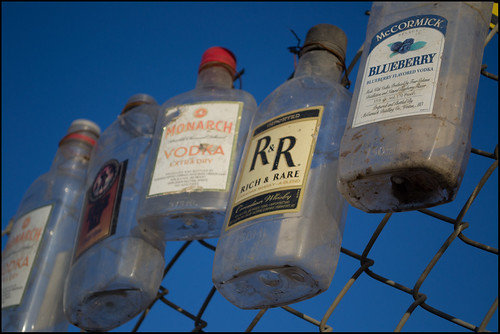
One is struck by how many bottles — 1,500 or more according to the ADN story, which also says they picked them up in just a few days without having to range very far in their search.  The bottles hang from the fencing, shine in the sunset light showing ironic brand names [Rich and Rare, Monarch, Southern Comfort].

Harry Mezak deserves recognition for this effort.  I hope to see more from him in the future.  He is following in a great tradition of activist visual art, whether he knows it or not.

Tagged , , , , , , ,

rod gonzales, 1948-2012

Just heard week or so ago that Rod was seriously ill and in the hospital.  Hoped he’d recover, but he didn’t and passed away Friday.

rod gonzales 1948-2012

Recent photo of Gonzales, courtesy Gonzales family.

I was introduced to him in 2010 and vaguely aware of him before then.  He was a prolific sketcher, painter and sculpture artist; a hockey fan; a devotee of Shannyn Moore and left-wing politics.  Most of his work I saw was poster-like, stream of consciousness type renderings that might look a little crude at offhand glance, but there’s a lot of depth in them, even as he’s unapologetic and tackles subjects head-on.   His written comments, some more coherent and linear; others a frenetic, choppy mixture of rapid-fire fragments were poetic themselves.

He had a family and they have lived for several years in Mt. View.  His hometown is Point Richmond, CA.

Rod’s son is an artist who has exhibited silkscreens and graffiti murals at the now-defunct MTS Gallery.  His son’s screen prints use high contrast, multi-colored separations and are a sophisticated approach for a young artist.  He will evolve into someone noteworthy, I predict.

Rod’s own art deserved a lot wider exposure than it received.  Since all I know about the man is what’s written above, I’m not sure if he desired to be published and exhibited or not.  He should have been doing covers for the Anchorage Press, had a solo gallery exhibition; or enjoyed half of Duke Russell’s acclaim and commissions by now.  Maybe this can be partially corrected posthumously, depending on his family’s wishes.

I’ll try to update this post later, as I learn more about him from people who knew him better.

Keep telling them the score, Rod, wherever you are now!

gonzales winkle

Congressman Don Young gets the treatment.

gonzales odalisque

Former AK Gov. Palin enjoys her New Money.

gonzales biodermus

Cover of graphic novel of the Oilpocalypse.

Tagged , , , , ,

defending mt. view to a skeptical public, again

I have made it a personal mission in the last 12 years to challenge people who make fun of Mt. View in some way in the public realm.  Here’s the latest salvo:

to: talkback@ktuu.com
from: clark yerrington
subject: “Viral Video Pokes Fun at Anchorage”

this story, one of the lead stories on your home page presently has an aspect that i find regrettable.

i know it is a satirical video.  i get that about it.
the part that bugs me is his nasty wisecrack about mt. view.
i have lived in mt. view since 1999 and have participated in the renovation and redevelopment of the neighborhood and community here.
many of us here are conscious of social problems, respectful of improvements, and engaged in ongoing discussions on how to make mt. view even better.
we don’t deserve to continue to be the punchline for people who are trying to feel better about spenard, or south anchorage, hillside, eagle river or wherever else.
let’s just go ahead and admit that ALL of anchorage has its problems, and ALL of anchorage has similar risk of being victimized by random violent crime.
or else, show me the statistics — not just folk wisdom or urban legend — proving that mt. view is less safe than the rest of anchorage.
KTUU’s prominent placement and story about the video says to me that you either agree that you’d have to be crazy to go door to door in mt. view, or else you find it funny.  either one is pretty disappointing.
Update: I got a prompt reply from Maria Downey [one of the anchors of the news program]:
Hi Clark,
Sorry you took offense to the piece.   It doesn’t mean we agree with all that is in the video at all.  The story was about  an award winning satirical piece that is getting a lot of attention on line from across the country.
The video pokes fun at many aspects of our life up here and I would say many Alaskans can  relate to much of the material and laugh about it but there might be some sore spots for others as well.
Thanks for sharing your concern about that one line in the video… we’ll share your feedback.
Maria
I still think there’s a big difference between joking about cracked windshields and winter weather, and the intentional marginalizing of a part of Anchorage.  But it was nice of her to write back.

Brilliantly beautiful cold afternoon

For a place that has been beleaguered, maligned, exploited, downgraded, disrespected and widely misunderstood — today it was simply beautiful.


Tagged , , , ,

‘scholastic art and writing’ at MTS

Here are a few images from the excellent primary/secondary student show, at MTS Gallery this month.

This will be one of the last shows at this location of MTS.  The building at 3142 Mt. View Dr., a former trailer manufacturing and parts sales facility has been used as a gallery, artist studios and the offices of the Anchorage Community Land Trust since 2006 but is scheduled to be torn down this spring.  Hopefully MTS will reappear soon at a different Mt. View location.  More on that story as it develops…

'Metro' by Deanna Strait

'Sole Searching' by Dorian Granger

'Ares' by Brooke Morgan

'Self Portrait' by Jessie Marman

'Family Freaks' by Christian Teston

'Brick In the Wall' by Devin Ball

Tagged , , , , ,

presenting my mt view house photos to APC audience


I was invited to show recent photographic work, along with three others to the monthly lecture audience of the Alaska Photographic Center.  I showed them my Mt. View house photos.  I’ve included all the photos in this post, and the captions below are approximately what I said about them as they were projected on the screen at the Anchorage Museum.

It was great to be on the program with the other three.  I’ve known Oscar for three or four years, seen him at Critical Mass bike rides… and a couple years ago he founded and ran a youth outreach project in the neighborhood, Mt. View Photo Voice.  This time he showed some highlights from a bicycle trip he made from Bellingham, WA to Colombia and back.

Charles Tice is an energetic and freewheeling young man who recently got that great moose shot on the flyer above.  Hearing how he did it was entertaining!  He has a future in photography, and knows it.  He is intentionally not letting himself get distracted with a day job, spending most of his time in pursuit of strong imagery.

Jackson is taking a deliberate, careful approach to portraiture and he showed a couple great ones, including a homeless man who sits at the entrance to the Homer Safeway store and does windshield chip repair to keep himself lubricated.

[There’s 79 photos here… I breezed through them all in 25 minutes or so.]


I’ve lived in Mt. View for 11 years and have been documenting it that whole time.  I’ve been specifically concerned about the disappearance of housing stock from the 1940-65 era.  The developed history of Mt. View can be chunked into four periods.  1920-40 it consisted of three adjacent 20-acre homestead parcels.  Each of the three original homesteaders subdivided their homesteads about 1940 and started selling lots.  Sales were slow at first, but picked up, post World War II.  A lot of houses were constructed from 1947 to 1952 to address a city wide post-war housing shortage.  From 1940 until 1965 the neighborhood was mostly single family dwellings, with a lot of trees and space between the houses.  Around 1965, the neighborhood’s zoning was changed, allowing apartment buildings to be built, coinciding with construction of the trans-Alaska oil pipeline.  Mt. View became the most densely populated part of Anchorage and became a transient area and developed crime and social problems, which continued through the 1970s and 80s.  In 1990 or so, the neighborhood entered its fourth and present phase, contemplating remaking its infrastructure, conditions and role in the city at large. 
This photo was sent to me by a woman in California I exchanged emails with in 2006.  The photo is of her house on Klevin St. south of Mt. View Dr.  She and her husband lived there for about a year.  The photo was taken in 1963.  The same location today, as near as I can tell is where the Glenn Highway, built 1965, cuts through.  The Glenn Highway bypassed Mt. View.  Before it was built, what is now Mt. View Dr. was part of the main road out of town, called the Palmer Highway.


When the Glenn Highway was built in 1965, this part of Mt. View Dr. was bypassed.  A vibrant commercial street in the 1950s and early 1960s, today it’s still frozen in time, looking neglected and unimportant.


This is an impromptu memorial to a 14 yr old who was killed by a random stray bullet in a drive-by shooting in 2004.  I’m not dwelling on this aspect, just including this to show that Mt. View’s reputation for violence and a lack of safety continue.


The landscape surrounding and within Mt. View is a major factor in its desirability and quality of daily life. There is a very old log house behind the fence, its lot full of tall, mature trees, shown here in Fall.


A wilderness trail through Davis Park, at the northeast corner of Mt. View.  This photo is from the You’d Never Believe You’re In Mt. View Department.


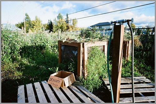
Community gardens are located at the northern edge of the neighborhood.  I have approached them many times, but they are difficult to capture effectively in photos.  I am going to keep trying.


There’s a neat homemade aspect to these gardens — fences made of found materials, all kinds of different plants… they are also used as an immersion program for new immigrants, who grow vegetables for sale and home use.


This is an alley, in the north middle part, near Mt. View Elementary School. It is lesser-travelled, and has the feeling of Mt. View in an earlier time. Overgrown with wild rose, grass and various other native vegetation. From June 2008.


Looking the opposite direction, from further down the same alley, later that summer.


An effective use of trees.  This line of aspens, along the fence between lots, provides some shade and visual interest for the people in the small blue house and their neighbors on the block.


I found it amusing, the way landscaping was deployed by the owners of this building.  There are no trees in the front yard — instead they are clustered along the sides of the building, very close.  That’s different!


Crabapple tree blossoms in early summer.


A dense cluster of trees [these are Mountain Ash, aren’t they?  I can’t remember right now], with some ferns, groundcover, what looks like chickweed and a broken down chain link fence provide a casual green street presence.


Sunset light illuminates a huge birch.  You can see a tiny house on the left and the Chugach Mountains beyond.


Mayday trees, in full bloom in June, and a small cottage.


There’s a house in there amongst the successful, mature landscape; making a nice atmosphere and degree of privacy.


All of the trees in the photo are on one lot, with one lot in the foreground and two behind being mostly or completely bare.  These trees are a shared amenity.


This photo shows how the pattern works on the scale of most of a block — smaller houses interspersed with mature trees and other types of landscaping. It is not an unpleasant scene, eh?


Looking north on Flower St.  All of the trees seen in the photo are on properties with older homes.  You can see that even the loss of a third, or half of them would drastically alter the appearance and character.  I met with a lot of focus groups of neighborhood activists, looking into planning and redevelopment issues — and they found that one aspect almost all residents said they appreciated was the trees!  So why don’t we figure out how to not lose them?


Here we see the border between commercial lots fronting Mt. View Dr. on the right and residential property to the left, separated by a cross alley.  What little landscape plantings remain in this area are because there are some older small homes remaining.  The two spruce trees sit on a lot occupied by a yellow house, barely visible in the photo.


Here is a site owned by Cook Inlet Housing Authority where they plan to develop a multifamily housing project. It’s relatively barren, but also gives an idea of how the area looked at times in the past.


A couple examples of pipeline era apartments. There were some larger buildings built then, but mostly fourplexes and some six-plexes. These buildings are good structurally, but the components — siding, windows and doors, appliances, finishes, mechanical and electrical systems are near the end of their useful life. Mt. View and Fairview were plagued with these buildings in the early ’70s, the peak of their construction being around 1974. Almost all of the lots in Mt. View are the same size, 50 ft wide by 125 ft deep. The small houses might cover only 10 percent of the lot area, leaving lots of room for yards, outbuildings and trees and shrubs. These buildings, you can see that most of the lot is paved, the pavement continuing right up to the street curb. There is maybe a 10 ft wide strip of grass on the back of each building, not very useable.


The typical approach used in the recent redevelopment efforts is to strip the entire property of all buildings, underground utilities and all trees and other plants.


The next stage of the project, with a foundation for a new duplex installed.  The same clearing and foundation work is proceeding on the block in the background, and a view corridor has been opened up that’s a lot different than a few months ago.  Where there used to be groves of spruce, there are now just isolated trees or small clusters.


This is by far the best single family home built by Cook Inlet Housing Authority.  It is the result of a design competition, won by architects Mayer Sattler-Smith.  It doesn’t look like the houses from the ’40s and ’50s but it is close in spirit — uniquely Mt. View, and a one of a kind design not repeated.


Unfortunately, to build the Ideal Home, the house pictured here was torn down.  This house had a strange long shed dormer in the front with a stained glass window, an enclosed porch and some other unusual features.  It may have originally been a log house, as many log homes in Anchorage were covered with stucco in the ’50s.


This is a typical new house that has been built the last couple years.  It is a nice design, in many ways.  But the developer’s m.o. seems to be: if you like it here, you will like it just as well on 14 or 16 other sites.  Sometimes another one sits just four or five lots down from the first one.


One of the same new houses, next to a 1940s or ’50s house that is ready for teardown.  An interesting juxtaposition of old and new.


This and the next two photos are of the same piece of property. This 1940s cabin sat on a corner lot at Klevin St. and Peterkin Ave. until 2004.


And this is the house built to replace it.  Contrary to usual practice, the spruce tree on the right was saved.  I guess they decided it wasn’t in the way.


This is the same house four or five years later.  Seeing this made me feel better, like some of these new houses will fit into the neighborhood.  It looks less generic now, with personal items displayed by the homeowner — and because the spruce tree is still there.


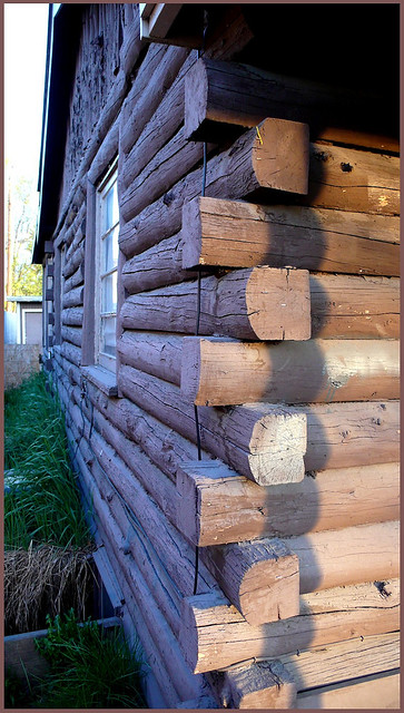
Another log house. I’m going to show a few log houses. An historic survey of Mt. View was commissioned by the Municipality of Anchorage in 2004 — and noted the presence of around 100 log buildings existing. I am guessing that has dwindled to around 20 or so today. This one, on Bragaw St. is in good shape and well-maintained. It has a basement, and a large addition and detached garage behind. A lot of room inside.


A small late 1940s cabin on a corner lot at Lane and Thompson.  Features shutters with cutouts shaped like trees, and a nice fence.


This very small tidy log home was torn down just this Fall. It sat very close to the road [closer than would be allowed today]. The owners lived there many decades and they always displayed a lovely flower garden in the front, including potted plants displayed on shelves attached to the wall of the house. The house sat on two lots and had a shed built out of old doors and a charming ramshackle greenhouse.


Log house on Bunn St. [I think]. Unusual in that it’s two stories. Have some older pictures of it under previous ownership, before the tree was limbed up and some of the other landscape features cut down. The house seems to be hanging in there.


1940s cabin on a corner lot at Bragaw and Thompson Ave. Also torn town this Fall. General front view.


Corner detail.


Looking at the entryway.


This house was kind of a wreck, but I loved the feeling of it — a weird little compound, out of whack with marginal buildings, strangely formed connections… and like a lot of the older homes, it’s not sitting square with the street and property lines.  Torn down in 2005.


Log house on Klevin St. with some of its logs painted blue.


And the front of the same building.  The strategy/procedure used for teardowns has been interesting.  First all of the plants are stripped off the lot, then the utility lines are cut off and meters removed, the windows covered with plywood and it’s just left sitting there for months on end.  I wish they would tear them down quickly.


Cabin further up Klevin St. sitting amongst tall spruce. Some of the older homes lack defining site elements — here there’s no driveway, porch or really anything except patchy grass and earth.


Thompson Ave.  Not completely sure, but I think this one [photographed last winter] is now also gone.  I liked how it has log sections covering the door.


I think this may be a conversion of an older single family home.  It may have been lifted up and a basement built under, and converted to a triplex or fourplex?  There are good and bad aspects here.  The good news is there’s fresh paint on the outside and it looks pretty together.  But the landlords, it appears have simplified maintenance by denuding the cottonwood and cutting off the aspen trees three feet above the ground.


Shotgun-style dwellings [there are two apartments in each building] with a small courtyard with huge spruce trees between. Appears to have been a separate property, later incorporated into the compound next door [to the right, not shown], an apartment building with a play yard that operated as a day care center in the ’60s, ’70s and ’80s. Seen in the background is a pipeline-era six-plex, casting a shadow over the older buildings.


There were a few other multifamily buildings in the original developed era.  These 1950s row houses sat on a large parcel on bliss st.  the building was hard against the alley, with a large yard area in front that was not dominated by parking.  There was lots of room for outdoor living.  This place always looked to be harmonious.  whenever i went by there in summer, there would be people sitting outside, barbecuing, lounging.  Seemed to be long-term tenants mostly.  Torn down in 2009.


This one puzzled me.  It is the size of a shed, about 8×12 ft., but it almost looks like it was set up for people to live there, and was [incredibly!] a duplex.  There are two other buildings, a main house and a detached garage on the same lot.


There are a few houses where there’s a fair amount of personal expression, like this backyard compound.


This house was a special sore point.  It should never have been torn down.  It was the best house from the original neighborhood, and one of the best from the 1940s in the city.  It was all original, on a concrete basement with a masonry fireplace.  It needed paint but in most ways was sound — the roof was fairly new.  This was a two owner home.  The 82 yr old owner died in 2003, having out-survived her husband by eight or ten years.  The couple bought the home in 1951 from the original owner.  Built in 1945.  Sat on three lots, fully landscaped.  She was a gardener and there were at one time 11 subspecies of lilacs in addition to many other native and other plantings.


Very small house on Schodde St., in good shape when torn down in ’06.


An even smaller one, though it doesn’t appear so in this odd view from behind a tall fence, in the alley.


I was always impressed by how well-kept this little place was. the lawn was always trimmed, the small trailer tucked neatly in the corner. Sat on two lots, occupied for decades by the owner. She passed away and the house isn’t there anymore.


This place is always likewise neat and orderly, and also has some kooky added roof forms.


Small house on Hoyt St., nearing its end.


Not a great photo of it, another very small house, this one at the corner of Flower St. and Parsons Ave.


Flower St. further south, resided in the ’60s/’70s but still displaying its original charm. Torn down 2010.


Another quite small, plain little place.  I heard that the owner lived next door and used to rent this house, but after a few tenants who had problems, he decided to just let it sit empty, but continue maintenance and upkeep.


Small, low houses.  Still there?


Hoyt St. house, slightly larger than some, still pretty tiny. about 600 sq. ft.


Flower St.  Cute, feel-good scenario.


Shows how plenty of space is left on the lot, with small house in the front.


Irwin St., 1947.  Still exists.


Typical arrangement for many of the early houses… small footprint, entry way may have been original, or perhaps added later to give a little more floor area, and a detached garage or shed.


Similar composition and features in a bit larger house.


The house is kind of a mess [easily fixed], a Quonset hut is seen beyond.  Classic Mt. View street.  Intersection of two alleys.


Irwin st.  Fun design, with twin dormers a bit overscaled for the house.


Hoyt St. House has a serious ice glaciering roof.  Technical problems, but the roof form is pleasing.  Built 1950.


Another one in its final days.


Park St.  three-lot mini-estate with small house right in the middle.  And carport and various sheds.  Planters made from tires, cut to resemble flowers, sitting on stumps; and other pleasing accents.


House had received an extension at rear and was converted into a triplex, though it still read as a single family home from the curb.


This doesn’t look like much, but it was the homestead house of Norman Lange, on Parsons Ave. One of the three homesteaders responsible for starting Mt. View.

And that is all I have!  Thanks!

Tagged , , , , , , ,

‘pop 11’ closes at MTS Gallery

A few people came by for the final day of Pop 11 at MTS.  The exhibition of Alaskan pop art was a part of the Pop 11 citywide mult-venue exhibit about Andy Warhol and the ’60s pop art revolution.


Multimedia installation by Nemo.


Mural on west wall by [l–r] Nemo, Esker, Alamander and Bisco, painted directly on the gallery wall.


Installation by Gariett Burtner.


Multiple works by Ferald and Kel explore homelessness.


Short film by Michael Walsh.

Tagged , , , , , , , , , , , ,